• Home
  • Biker's Blog
  • Downloadable Maps
  • Pictures of Patriots Path
  • Directions
  • Trail Updates
  • What is Patriots Path?
  • Trail Info
  • Lenape Trail
  • Liberty Gap Trail
  • Highlands Trail
  • Other Cool Trails
    • Buttermilk Falls State Park
      • Dismal Harmony Brooks Nature Area
        • Schooley's Mountain Park
          • India Brook Nature Area
            • Buttermilk Falls Natural Area
            • Contact Me

            Updates 2-27-12: 
            Blog, Map Update, Directions


            Welcome To The Unofficial Site of Patriots' Path
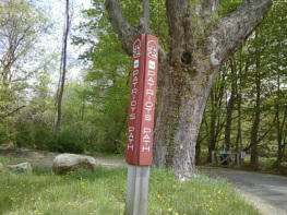
            Picture
            Patriots Path sign at Heistein's Pond
            This website allows the viewers to look and view exclusive maps of this trail.  I made the maps based on what I've hiked and seen.  The maps provided by the county restrict accuracy and have proposed routes.  The trail maps I've provided show the most accurate views of Patriot's Path and ensure accuracy.  These maps map all parts of the trail, most are accurate, some will be tweaked as I hike the trail, so make sure you have the most updated trail information.  Hope these maps will help with knowing where the trail access points are.


            Other Features of This Site

            Picture
            Patriots' Path at Furnace Road
            This site also provides updates of reroutes, and extensions.  Also, I provide trail reviews in my blog, and pictures of the trail.  I also have pictures of other trails I like to hike and bike.  I have directions telling you where trailheads are and lots more!
            Contact me if you have any comments, concerns, or questions.

            Hikes Every Week

            Picture
            Patriots' Path at Hugg Road
            Every weekend I go on a hike down a trail somewhere.  Check my Blog for reviews, and check Pictures or Other Cool Trails for pictures of the trail.  Hope you find this information helpful.
            Trail Updates will tell you when a trail section is completed or rerouted.
            When I update the site I put at the top what I updated to guide you to the new information.
            Some weekends I do not go on a hike because of weather or other issues with the trail.


            Picture
            (From right to left) Me, Steve Marano (Chairman of Lenape Trail), Al Kent (the founder of Patriots' Path), and two other hikers in Bee Meadow Park

            Google Earth on my website is coming soon but for now if you have the Google Earth Application, click here to access the page to download a trail overlay. 
            If you don't have the application and you don't want it, use the map below to access as much of the trail provided by Google Maps.
            Create a free website with Weebly